Saturday, September 5, 2020
Pizza corruption scandal risks dragging China into Pakistan’s domestic affairs

Pakistan's Foreign Minister Shah Mehmood Qureshi, centre, unveils the country’s updated official map which for the first time includes large parts of Indian-administered Kashmir. Photo: EPAPakistan's Foreign Minister Shah Mehmood Qureshi, centre, unveils the country’s updated official map which for the first time includes large parts of Indian-administered Kashmir.
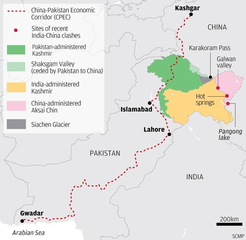
Pakistan’s move to unveil a new political map reasserting its claim to all of Indian-administered Kashmir – minus the parts claimed by China – is fuelling New Delhi’s fears of a two-front conflict with its neighbours, despite a lack of evidence that such a move is in the works. But the release of the map is the latest in a series of conflicts born from cartography which have broken out in the Himalayas since May – from a deadly scuffle between Indian and Chinese soldiers in mid-June to a war of words that began earlier in the summer when New Delhi opened a road through territory claimed by Nepal.
Pakistan’s new map – unveiled almost exactly a year to the day since India’s unilateral decision to strip the part of Kashmir it controls of its semi-autonomy – extends Islamabad’s territorial claim north-eastward up to the Chinese-held Karakoram Pass. On paper, the map links Pakistan with Chinese-administered territory via the Shaksgam Valley, a part of the Gilgit-Baltistan region ceded to China by Pakistan under their 1963 border settlement. To the east is the Aksai Chin region – the limit of China’s claims in Kashmir which it has controlled since a 1962 war with India.
Between the two lies the Siachen Glacier, an undefined area at the northern extreme of the de facto border between Pakistani- and Indian-administered Kashmir known as the Line of Control – not to be confused with the Line of Actual Control, which separates Indian- and Chinese-controlled territory in the region.India, like Pakistan, claims Kashmir in its entirety and has no interest in pursuing a United Nations-supervised plebiscite, supported by Islamabad, for the region’s residents to decide which country they should join. The recent incursions by China across the disputed Line of Actual Control into Indian-administered Kashmir have given Beijing the ability to impede India’s military traffic along roads approaching the Siachen Glacier from the east.
To this extent, Pakistan’s new map does hint at the possibility of coordinated operations with China if Islamabad ever attempts to forcibly take the glacier, which would create a land bridge between Gilgit-Baltistan and Chinese-administered Aksai Chin.
Since Chinese and Indian forces clashed in the Ladakh region this summer, Indian media have speculated about China’s strategic intentions in the area, including the possibility of it seeking to seize territory – fuelling fears of a future war with both China and Pakistan.
“This certainly reinforces the Indian perception of a two-front theatre that its military planners are increasingly taking into account,” said Harsh V. Pant, a professor of international relations at King’s College London.
But as Ejaz Haider – a Lahore-based South Asian strategic affairs analyst – points out, a highway connecting Tibet to Xinjiang already exists “so the Chinese don’t need a route through the Karakoram Pass to reach Xinjiang”. That being said, if Pakistan’s new map were to become reality, it would represent a “net strategic gain” for both Islamabad and Beijing, the former Ford Scholar with the University of Illinois’ programme on arms control, disarmament and international security said.
In a rare four-way dialogue with his counterparts from Pakistan, Afghanistan and Nepal last month, China’s Foreign Minister Wang Yi again pushed plans for a trans-Himalayan economic corridor connecting Nepal to Pakistan via Tibet and Xinjiang, from where it would join the estimated US$60 billion China-Pakistan Economic Corridor (CPEC) culminating at the Chinese operated port of Gwadar on the Arabian Sea. Wang also called for the extension of the CPEC into Afghanistan.
Michael Kugelman, senior South Asia associate at the Washington-based Wilson Centre think tank, said the strategic value of Pakistan’s new map, for Beijing, may lie in the additional political cover it provides to belt and road projects being built in Pakistan-administered Kashmir and Gilgit-Baltistan.
The new map is significant because “it recognises large areas of Indian territory as Pakistan’s”, he said. “This is presumably meant to be a defence of the Belt and Road Initiative, which India opposes because it runs through disputed territory that it claims.” In June, Pakistan awarded contracts for the construction of three major hydropower projects along the Neelum River to Chinese state-owned enterprises under the CPEC programme.
The Neelum River marks the divide between Indian- and Pakistani-administered territory in western Kashmir, before it merges with the Jhelum River, a major tributary of the Indus. This in turn supplies water from Himalayan glaciers to an estimated 270 million people in Pakistan and northwest India.Asma Khan Lone, author of an upcoming book on the history and the geopolitics of the region called The Great Gilgit Game, drew a parallel between Pakistan’s new cartographic claim to the Indian-held Siachen Glacier – a huge source of fresh water – and China’s efforts to “weaponise water” in Ladakh by building dykes for what she described as “tactical flooding”.
Previously vacant because of its extreme altitude, the Siachen Glacier was occupied by Indian forces in 1984, prompting years of intermittent fighting between India and Pakistan at an average elevation of more than 5,400 metres above sea level until a ceasefire was agreed in 2003. The glacier is notorious for killing far more soldiers with its extreme environment than enemy artillery shells ever did: in April 2012, 129 soldiers and 11 civilian contractors were killed after an avalanche buried a Pakistani military base in the nearby Gayari sector. The huge cost of waging war on the glacier, both in terms of finances and human lives, has so far prevented skirmishes breaking out there in the same way they have done elsewhere along the Line of Control since 2016.
But tensions are on the rise. In February last year, Indian warplanes crossed into Pakistani air space near the glacier. Delhi has also recently started reasserting its claims to Pakistan-administered Gilgit-Baltistan and Kashmir by including both in the country’s official weather forecasts since May, while Indian military chiefs have declared their forces ready to seize the territory if so ordered. Kugelman of the Wilson Centre said Pakistan’s new political map is “presumably meant to push back” against such threats – but like India’s bombast, he said it is driven more by domestic politics than long term strategic plans.
“I don’t think we should read too much into this map,” he said. “It is just the latest subcontinental case of using cartography to appeal to nationalism at home, while taking a shot at the enemy next door.”
Zhou Rong, a senior fellow at Renmin University’s Chongyang Institute for Financial Studies who has researched Pakistan and Afghanistan, said the risk of a fourth war between Delhi and Islamabad over Kashmir was very real. “India also realises that ties between Pakistan and the US has become less important over the years, and that Washington has stood on its side during its conflicts with Pakistan,” he said. “This has enabled India to become even more confident.”
He added that “many countries are unwilling to offend India” as they are “increasingly reliant” on it economically. “Many traditionally Islamic countries have also forged better relationships with [New] Delhi, seeing it as an important market for their energy exports,” he said. https://www.scmp.com/week-asia/politics/article/3096308/pakistans-new-kashmir-map-links-it-china-fuelling-indias-fears
Ahead of #FATF Plenary, New Document Reveals Hizb Chief Syed Salahuddin's Direct Links to Pakistan's ISI
As Pakistan’s performance in implementation of the Financial Action Task Force (FATF) Action Plan comes up for review in October, there is mounting evidence of Islamabad’s continuing support to terrorism in general and active connivance in financing terrorism in particular. A new document accessed by security agencies confirms links of one of its proxies with Pakistan’s Inter-Services Intelligence (ISI), which is likely to further muddy the waters as its Grey Listing is taken up at the FATF plenary.As Pakistan’s performance in implementation of the Financial Action Task Force Action Plan comes up for review next month, there is mounting evidence of Islamabad’s support to terrorism in general and active connivance in financing terrorism in particular.

One of the important terrorist groups that have been used by Pakistan to foment terrorism in India is Hizbul Mujahideen (HM), headed by Mohammad Yusuf Shah, also known as Syed Salahuddin. He is also the head of the United Jihad Council (UJC), an umbrella organisation of terror outfits such as Lashkar-e-Taiba (LeT) and Jaish-e-Mohammed (JeM).
Acting on the instructions of his Pakistan masters, Salahuddin has been instrumental in carrying out anti-India propaganda and terror activities in Jammu and Kashmir. He has time and again accepted Pakistan’s role in funding terrorist and secessionist activities in Kashmir. In an interview in June 2012, Salahuddin had admitted that he was fighting Pakistan’s war in Kashmir, even threatening to take the war to Islamabad if it withdrew support to him.
Salahuddin had also announced that "the Mujahideen struggle serves as a defence line for Pakistan". The arrest of his sons Syed Shakeel Yousuf and Syed Shahid Yousuf and the recent killing of two of his close associates Riyaz Naikoo and Adil Ahmed by Indian security forces (on May 6) seemed to have rattled Salahuddin, making him increasingly desperate.
Salahuddin supports terrorist activities on Indian soil through a number of proxy NGOs and charities supported by the ISI and other Pakistan-based entities. Among the most prominent of these is the Jammu and Kashmir Affectees Relief Trust (JKART).
The JKART is used by Salahuddin to find recruits by offering them financial incentives and promising to take care of their family members once they are "martyred". JKART’s head office is in Rawalpindi with branches in Islamabad, Muzaffarabad (PoJK), among others.
Indian security agencies recently obtained specific evidence of direct links between ISI and Salahuddin. A letter issued in the name of Mohammad Yusuf Shah alias Syed Salahuddin certified that he is a bonafide official of the Directorate of Intelligence and is working for the ISI. The letter even suggested that he has been “security cleared” and should not be “unnecessarily stopped”. The certificate is valid up to December 31, 2020. The letter issued Shah is important for the FATF to see before taking a decision.
It may be mentioned that it is not Salahuddin alone who enjoys VIP treatment from the Pakistani establishment. It is estimated that Pakistan shelters around 130 terrorists sanctioned by the United Nations Security Council (UNSC). It has also been disclosed that Pakistan has provided access to these terror outfits to its banking system for carrying out nefarious terror activities in India and elsewhere. Recent chargesheets filed by the Enforcement Directorate (ED) and the National Investigation Agency (NIA) bring out the linkages between terrorists and the Deep State in Pakistan. This is likely to be viewed seriously by the FATF as it reviews Pakistan’s Action Plan next month.
https://www.news18.com/news/world/ahead-of-fatf-plenary-new-document-reveals-hizb-chief-syed-salahuddins-direct-links-to-pakistans-isi-2852545.html
#Pakistan #PPP - Chairman PPP Bilawal Bhutto Zardari demands postponement of NA session

Chairman PPP said that the members need to be with their people at this time of need. Former Prime Minister Raja Pervaiz Ashraf has already requested the Speaker National Assembly for this postponement. Bilawal Bhutto Zardari said that the situation is very serious in several part of the country due to heavy rainfall.
Bilawal Bhutto Zardari said that in the current situation, all the government and opposition political parties should aim for relief work for the victims of torrential rain.
https://www.ppp.org.pk/pr/23701/
Subscribe to:
Posts (Atom)